New Shuswap mapping resource available
The Shuswap Watershed Project has been continuing to work on tasks that improve understanding, appreciation and protection of the Shuswap watershed. Since the release of the groundbreaking map poster in March, 2010, the Project’s website, shuswapwatershed.ca , has been expanded and improved with the addition of many resources, including an educational handbook, images, the winning salmon and Shuswap songs and a section on history with archival documents.
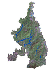
Recently, a new set of maps was added that provide more details about each of the sub-drainages in the Shuswap watershed. There are 12 major sub-drainages within the watershed that range in size from the very small 21,000 hectare Wap Creek watershed to the very large 440,000 hectare Shuswap River watershed. In addition, there is a map of the smaller drainages surrounding Shuswap Lake.
“These maps provide an invaluable resource for students, backcountry enthusiasts, researchers and anyone with a curiosity about our region’s geography,” said Project leader, Jim Cooperman. Already one Salmon Arm Secondary teacher, Dave Ramsay, is excited about using these maps in the upcoming school year for his newly developed course on the Shuswap watershed.
For each of these watersheds, there are actually three map files available for downloading on the website. One is a topographic map that includes the water features. The other two maps use satellite coverage for the base and one is a PDF file that can be shared easily and the other is jpeg file that can be modified. All of the maps are designed to be printed in colour on 11 x 17 inch paper or viewed on a screen.
The colour maps show a key feature that until now has not been available for public viewing, all the old growth management areas (OGMAs), which range in size from a few hectares to hundreds of hectares. The designation of OGMAs is a key component of the province’s biodiversity protection plans, as old growth forests provide critically important habitat for many species that cannot survive in clearcuts and plantations. These old growth areas were chosen during the land use planning process over a decade ago and they are protected from logging and road building.
Perhaps the most familiar OGMA for Shuswap residents in the one in the Larch Hills that includes the well appreciated trails in the North Hub area that wind past the giant white pine, red cedar, Douglas fir and hemlock trees. Anyone that is interested in ecology or would like to visit an ancient forest to see what the Shuswap landscape looked like prior to the era of resource extraction can use the maps to locate these majestic, giant trees.
Another use for these sub-drainage maps designed by Silvatech Consulting would be for comparing one area with another. Some drainages, such as Celista Creek, Momich River/Cayenne Creek, Scotch Creek, Anstey River and Wap Creek are void of human habitation, while in others the communities are for the most part located adjacent to lakes or streams. The watershed that contains the largest population, Salmon River, is also the most modified, primarily from intensive agriculture, logging and cattle grazing.
The maps also show where there are extensive wetlands, alpine areas, clearcuts and plantations. The names for many of the smaller creeks are listed. It should be noted that there are many creeks and small lakes in the Shuswap watershed that are unnamed. This lack of names points to one interesting characteristic about our region, that except for forestry workers and occasional fisherman and hikers, few people ever venture into much of the backcountry.
The sky is the limit for what one can do with the jpeg images of the sub-drainages maps. On the screen, the images are sharp enough to allow one to zoom into any area of interest to view roads and individual parcels of private land. The jpegs can also be cropped to create new maps, which can then be further modified. Feedback about this new mapping initiative is welcome via the website. “We look forward to hearing from users of this new resource about different ways these maps can be utilized, added Cooperman.